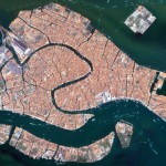
 The whole world knows the situation of Venice, Italy: the city is slowly sinking. Is the fault of man or nature , or both is not yet given to understand in detail. It is for this reason that from time to time satellite analisys is necessary to verify how much the lagoon city is demeaning. And, when it’s possible, to check how much it is fault of nature and how much of man, so to take appropriate measures .
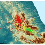
In a new study published by Nature, a team of researchers has used radar images collected from 4 different satellites, to which they have applied the analysis technique known as PSI (Persistent Scatterer Interferometry), thus obtaining data that allow a resolution than was previously impossible.
|
The satellites used are the ERS, Envisat, the Tit X and CosmoSkymed, a jewel built by the Italian ASI. With these satellites, it was possible to determine the lowering of Venice caused by nature and lowering caused by man. The results? Are clearly visible in the map below. Venice is sinking an average of 1 millimeter per year, in some parts, however, human activity has worsened the situation to the point that some areas are lowered by about 5-10 millimeters per year (these are the areas in red), but there are also places where human interventions have reduced the margin collapse (in the map are shown in green). [Read this article in italian | Leggi in italiano] |

ALTRI ARTICOLI CHE POSSONO INTERESSARTI
 ECCO COME VENEZIA STA SPROFONDANDO. LA MAPPA
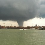 FOTO E VIDEO: VIOLENTA TROMBA D’ARIA SU VENEZIA, DANNI IN LAGUNA
 ECCO IL CALCOLATORE DEL CONGUAGLIO IMU. SCADENZA 17 DICEMBRE
- TROMBA D’ARIA A VENEZIA: 4 MILIONI DI DANNI ALL’AGRICOLTURA
 Alla biennale L’Aquila si vergogna
 Report Popolazione Assistita al 14 settembre 2010


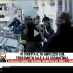


 6APRILE.IT E' UN BLOG SENZA SCOPO DI LUCRO! sul terremoto che ha ucciso 309 persone a L'Aquila il 6 aprile 2009. Viene aggiornato senza alcuna periodicità e pertanto non è da considerarsi una testata giornalistica o in ogni caso un prodotto editoriale ai sensi della legge n.62 del 7.3.2001. L'obiettivo è quello di ricordare le vittime e sostenere le persone che stanno ancora affrontando gli effetti di quella tragedia e dei successivi terremoti del 2016 e del 2017. Tutte le immagini di questo sito sono ampiamente diffuse su Internet e sono qui utilizzate senza alcuno scopo commerciale; non è intenzione di questo sito appropriarsi indebitamente dei contenuti protetti da diritto d'autore, quindi se detenete il copyright di qualsiasi contenuto, contattateci e (secondo vostra indicazione) lo rimuoveremo o ne indicheremo l'autore. Un ringraziamento speciale a tutte le persone che aiutano questo sito a restare in vita.
 6APRILE.IT IS A NON-PROFIT BLOG! about the earthquake which killed 309 people in L'Aquila, Italy, on 6 april 2009. The aim is to remeber the victims and to support local popuation which is still facing the effects of that tragedy and of the subsequent 2016 and 2017 earthquakes. All pictures and other media on this site are widely spread on the internet and are used here without any commercial purpose; it is not the intention of this site to misappropriate copyrighted content, so if you own the copyright of any content, just contact us and we will remove it. Special thanks to all the people who help in keeping this website alive.